
Arizona Flash Floods: Rescues and One Death as Southwest Braces for More Rain
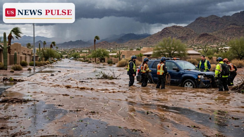
Arizona flash floods turned deadly on Friday and forced a string of swift-water rescues across the Phoenix area, just as a new atmospheric river began pushing more heavy rain into an already saturated Southwest. Flood watches now cover nearly all of Arizona and parts of four neighbouring states through Monday, and forecasters warn that even modest additional rain could trigger rapid flooding on soaked ground.
Key Points
- One person died in Henderson, Nevada, after being rescued from a wash during Friday's downpour; three swift-water rescues were carried out there.
- Phoenix firefighters rescued people from four vehicles on flooded streets on Friday night, and Scottsdale crews rescued three people from two vehicles in water 3 to 4 feet deep.
- Flood watches cover nearly all of Arizona plus parts of southern Utah, southwestern Colorado, western New Mexico and southern Nevada through Monday, November 2.
- Forecasters expect up to 4 inches of additional rain in places, with 4 to more than 6 inches possible on some Arizona slopes facing the incoming moisture.
- The same system then heads east, bringing soggy weather to the central United States on Election Day, Tuesday, November 3.
What Happened
The trouble arrived in stages. On Friday afternoon and evening, intense bursts of rain fell on desert cities whose washes and streets were already running high after a wet autumn. In the Phoenix area, parts of Paradise Valley received 2 to 3 inches of rain in just three hours, from 5 p.m. to 8 p.m. on Friday, while much of north Scottsdale received 1 to 2 inches, according to local reports cited by WeatherBoy. More than 5,000 Salt River Project and Arizona Public Service customers lost power at the height of the storms, and about 1,000 Arizona Public Service customers were still without service around 9 p.m.
The Phoenix Fire Department said it rescued people from four vehicles on flooded streets on Friday night. In nearby Scottsdale, fire crews rescued a person in one vehicle on a flooded street when another vehicle carrying two people drove into the same waters and also had to be rescued. Scottsdale police closed Shea Boulevard between 64th and 70th streets because of downed power lines and closed the intersection of Scottsdale and Deer Valley roads because of flooding.
In Henderson, Nevada, just outside Las Vegas, city officials confirmed three swift-water rescues during Friday afternoon's downpour. One person was rescued from the roof of a vehicle trapped in floodwaters, two people were pulled from a vehicle swept from the roadway, and a person found in a wash was rescued but then went into cardiac arrest and died at a hospital. In Bullhead City, Arizona, on the state's border with California, heavy rain left water, rocks and debris across streets and forced the city to close parks.
Background/Context
The Southwest has endured what the National Weather Service and local reports describe as a deadly autumn of soaking rains, with repeated systems saturating soils and filling normally dry washes. That history matters because saturated ground cannot absorb much more water: rain that would normally soak in instead runs off quickly into streets, washes and small streams. The Weather Prediction Center's excessive rainfall outlook for Sunday, November 1, issued on Saturday, October 31, placed a Moderate Risk over parts of the Four Corners region, where Arizona, Colorado, New Mexico and Utah meet.
Forecasters describe the incoming system as an atmospheric river — a narrow corridor of deep tropical moisture — riding in from the Pacific. The Phoenix weather service office said atmospheric moisture would surge above the climatological maxima for this time of year on Saturday night into Sunday, while the Tucson office described the system as a level 3 atmospheric river on a 1-to-5 scale and said moisture levels could approach or reach records for November. Tucson forecasters wrote that rainfall records for November 1 could fall across much of the area.
Arizona Flash Floods: Watches, Rainfall Totals and the Roads at Risk
The National Weather Service has issued flood watches for nearly all of Arizona and parts of southern Utah, southwestern Colorado, and western New Mexico, in addition to part of southern Nevada. The Flagstaff office placed all of northern and central Arizona under a watch from 11 p.m. Saturday through 5 a.m. Monday, warning of flash flooding caused by excessive rainfall over saturated soils and forecasting an additional 1 to 3 inches of rain. High-resolution models showed 4 to more than 6 inches possible on slopes facing the incoming moisture, with at least 1 to 3 inches, and locally 4 inches, elsewhere. Forecasters said larger waterways, especially the Little Colorado and Verde rivers, may be flooding for days after the event.
In the Phoenix area, forecasters expect 0.75 inch to 1.75 inches of rain, with 2 to 4 inches, and locally more, over the foothills and higher terrain to the north and east. A separate watch covering Tucson, Nogales, Sierra Vista, Safford and the surrounding mountains runs from 11 p.m. Saturday to 5 a.m. Monday, with potential for significant rises on the San Francisco and Blue rivers, the Gila River and Sabino Creek, and minor to major flood stages possible. As much as 4 inches of rain could fall across the wider region, according to the Weather Prediction Center's Allison Santorelli, a meteorologist in College Park, Maryland, who said this weekend's rain was expected to bring both flash flooding and small-stream flooding.
Higher elevations face a different hazard from the same system. Forecasts cited by the National Weather Service indicate 12 to 18 inches of snow in the San Juan Mountains of southwestern Colorado, creating hazardous travel on mountain roads, especially Sunday night into Monday morning. The storm is then expected to march into the central United States by Election Day.
Reactions/Quotes
Scottsdale Fire Captain Dave Folio warned in a video posted on Facebook that shallow water is no protection. "Just 2 inches of water can sweep your vehicle off its wheels," Folio said, describing vehicles caught in water measuring 3 to 4 feet deep. His warning echoes the central safety message from every agency involved in the weekend response: a flooded road can hide a washed-out surface, a moved manhole cover or a curb, and a vehicle that looks stable can be carried away in seconds.
Weather service forecasters have been blunt about the setup. The Flagstaff office's watch language — flash flooding caused by excessive rainfall over saturated soils — is the reason watches stretch so widely this weekend: it is not one city's storm, but a regional event falling on ground that has no capacity left. Local crews have already responded to flood emergencies, rescuing multiple people from flooded vehicles in the Phoenix and Scottsdale area and dealing with water, rocks and debris that closed streets and parks in Bullhead City.
Why It Matters
This is not only a desert weather story. It is a test of how quickly a saturated landscape turns a forecast into a rescue — and, in Henderson, into a death. The Friday rescues happened before the main atmospheric river even arrived, which is why forecasters are urging residents not to judge Sunday's risk by Saturday's sky. When soils are saturated, the margin between a heavy shower and a life-threatening flash flood shrinks to almost nothing, and desert washes can rise with little warning.
The timing also matters nationally. The same system that soaks the Southwest this weekend is the system expected to bring soggy weather to a wide area from the Great Plains and Upper Midwest to the Lower Mississippi Valley and the western Gulf Coast on Tuesday, Election Day. Voters travelling to the polls could encounter ponding on roads, and thunderstorms are possible on the storm's southern side, a few of which could intensify and turn severe from eastern Texas into Arkansas, Louisiana, Mississippi and Tennessee. Blustery conditions are also likely across much of the Plains, with Kansas wind gusts of 30 to 40 mph, up to 50 mph in Nebraska.
What Happens Next
The immediate threat runs through Monday. Flood watches across Arizona and the neighbouring states remain in effect into the early hours of Monday, with lingering flooding and elevated water levels expected to continue into Monday even after the heaviest rain passes. Mountain snow in Colorado will make southwestern mountain roads slick and hazardous Sunday night into Monday morning. Residents are urged to follow National Weather Service and local emergency updates, to avoid driving through flooded roads, and to keep clear of washes, creeks and rivers that may keep rising after the rain stops.
From Tuesday, attention shifts east with the storm. Forecasters will refine the Election Day track over the weekend as confidence grows, but the broad picture — a soggy central United States, severe thunderstorms possible in the south, and gusty winds on the Plains — is already set. Any new confirmed flooding, road closures or casualties from the Southwest weekend will be reported as a follow-up to this story.
FAQ
Which states are under flood watches? Nearly all of Arizona, plus parts of southern Utah, southwestern Colorado, western New Mexico and southern Nevada, with watches running through Monday, November 2.
How much more rain is expected? Up to 4 inches in places across the region, with 1 to 3 inches widely expected in northern and central Arizona and 4 to more than 6 inches possible on some moisture-facing slopes.
Did anyone die in the Friday flooding? Yes. In Henderson, Nevada, a person rescued from a wash went into cardiac arrest and died at a hospital, city officials said. Three swift-water rescues were carried out in Henderson on Friday.
Why is flooding so dangerous in the desert? Desert soils and washes can be saturated after repeated storms, so new rain runs off fast instead of soaking in. Just 2 inches of moving water can sweep a vehicle off its wheels, according to Scottsdale Fire Captain Dave Folio.
Will the storm affect Election Day? Yes, the same system is expected to bring soggy weather to the central United States on Tuesday, November 3, with ponding on roads possible and severe thunderstorms possible in parts of the south.
Related coverage on US News Pulse: Four Corners flood risk: Moderate Risk warning for November 1 heavy rain, Election Day storm could soak key midterm states and dent turnout, and Halloween weather forecast 2026: rain, storms and flood risk hit Texas and the Plains.
© 2026 US News Pulse. All rights reserved.
 Print
 Save