
Flash Flood Emergency as 15 to 20 Inches of Rain Swamp Palm Bay, Florida
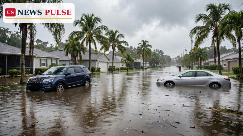
A rare Flash Flood Emergency — the National Weather Service's highest flood warning — was extended across Palm Bay, West Melbourne and Grant-Valkaria in Brevard County, Florida, on Monday, November 2, 2026, after between 15 and 20 inches of rain had already fallen, with officials calling the damage threat catastrophic and urging residents to stay home and off flooded roads.
The escalation is a major new development in the same Brevard County flooding that closed schools on Monday morning, when totals were far lower. By late morning the Weather Service was warning of a particularly dangerous situation, stalled vehicles in Palm Bay, closed roads across Melbourne, and 2 to 4 more inches of rain still possible on ground that was already saturated.
Key Points
- A Flash Flood Emergency covered West Melbourne, Palm Bay and Grant-Valkaria in southeastern Brevard County, extended until 1:45 p.m. on Monday, November 2, 2026.
- Between 15 and 20 inches of rain had fallen in southeastern Brevard by 11:35 a.m., with 2 to 4 more inches possible; the Weather Service rated the damage threat catastrophic.
- A separate flash flood warning for east central Brevard ran until 3 p.m., with 8 to 10 inches reported in Melbourne, Satellite Beach, Indialantic, Merritt Island and Eau Gallie.
- Brevard Public Schools closed for the day, county government facilities closed, and Brevard Emergency Management told residents to stay home and off the roads.
- Radar estimates of 18 to 20 inches in 12 hours just south of Palm Bay exceed the 15.5-inch threshold NOAA cites for a 1,000-year flood event.
What Happened
The flooding built through the night and kept intensifying on Monday. The National Weather Service office in Melbourne issued a flash flood warning for southern Brevard County at 4:44 a.m., reporting between 6 and 8 inches of rain already fallen and calling the flooding life threatening. A second warning for northern Brevard, covering Titusville, Mims and Port Saint John, followed at 4:58 a.m.
At 6:30 a.m. the Weather Service said a stalled boundary was still producing training bands of showers and storms — repeated storms moving over the same places — with heavy rain. By 7 a.m. Brevard Emergency Management reported widespread road flooding, especially in the south end of the county, and confirmed that Brevard Public Schools had cancelled classes for the day.
At 7:56 a.m. the Weather Service raised the warning to a Flash Flood Emergency for West Melbourne and Palm Bay, initially until 9:45 a.m., reporting between 8 and 12 inches of rain from radar and automated gauges, with 4 to 6 more inches possible. The warning said, in capital letters, that this was a particularly dangerous situation and told people to seek higher ground and not to travel unless fleeing a flooded area or under an evacuation order. It rated the flash flood damage threat as catastrophic.
The totals kept climbing. At 9:34 a.m. the warning reported between 12 and 15 inches, with 3 to 5 more inches possible. At 11:35 a.m. it reported between 15 and 20 inches, with 2 to 4 more inches possible, and the emergency was extended until 1:45 p.m. for southeastern Brevard, covering West Melbourne, Palm Bay and Grant-Valkaria. Fox Weather reported radar estimates of 18 to 20 inches in 12 hours just south of Palm Bay, and noted that, according to NOAA, anything over 15.5 inches in 12 hours makes this a 1,000-year flood event.
Brevard Flooding: Closures, Roads and Safety Warnings
Melbourne police reported flooding throughout the city and closed a string of roads, including Babcock Street at University Boulevard, all of Dairy Road and Lake Washington Road, Aurora Road near Stewart Road, and Sarno Road near Eau Gallie Boulevard. The department's message was blunt: stay home and avoid flooded roadways.
Brevard Emergency Management said at 11:45 a.m. that the safest way to handle flooded conditions was to stay home and off the roads whenever possible, noting that vehicles create a wake that can push water into homes and yards. It also posted a damage self-report form for residents whose homes had flood damage, stressing that the form helps assess community impacts and is not an application for assistance.
County government closed its facilities on Monday, while the Supervisor of Elections office in Viera stayed open for Tuesday's election — a detail that matters on the eve of the November 3 midterms, when Brevard voters are due at the polls. Emergency management also warned that portions of Interstate 95 could have standing water, and asked residents to limit water use, such as keeping showers short and running dishwashers only when full, because the rain was putting stress on the wastewater system.
Elsewhere in the county, a flood warning for central Brevard, including Titusville, Cocoa and Rockledge, ran until 2 p.m., and a warning for southern Brevard and northern Indian River, including Micco and Barefoot Bay, ran until 1:45 p.m. A new flash flood warning for east central Brevard ran until 3 p.m. for Melbourne, Satellite Beach, Indialantic, Merritt Island, Indian Harbour Beach and Eau Gallie, where 8 to 10 inches had fallen. South of Brevard, Port St. Lucie and Fort Pierce faced a flash flood warning with up to 8 inches of rain, and a coastal flood advisory was in effect for possible saltwater flooding around high tide.
Reactions/Quotes
The Weather Service's own language carried the urgency. Its emergency warning called the situation particularly dangerous, told residents to seek higher ground now, and rated the damage threat catastrophic — the strongest wording in its flood-warning scale. Its 11:35 a.m. update kept that catastrophic rating even as the emergency was extended.
Brevard Emergency Management's 11:45 a.m. message reinforced the same point in practical terms: stay home, stay off the roads, and remember that driving through floodwater does not only endanger the driver — the wake can push water into neighbours' homes and yards.
Local reporting captured the scale on the ground. Launchpad Digital video recorded on Monday at Palm Bay Road and Claremont in Palm Bay showed standing water across a backyard lawn and across open ground near homes as rain kept falling, and Fox Weather reported vehicles stalled in the water in the Palm Bay area after the Flash Flood Emergency was issued for Brevard County.
Why It Matters
This is no longer an ordinary heavy-rain day. Totals of 15 to 20 inches, and radar estimates approaching 20 inches in 12 hours, put parts of Brevard County into territory the Weather Service reserves for its rarest warnings. Saturated ground, a stalled boundary producing repeated storms, and another 2 to 4 inches still possible meant that even a modest additional burst could worsen flooding that was already catastrophic in places.
The timing compounds the impact. Schools and county offices were closed, roads across Melbourne were shut, and the flooding arrived the day before the November 3 midterm elections, when election offices, polling places and voters all need passable roads. The Supervisor of Elections office in Viera staying open was a deliberate exception, but flooded approaches elsewhere in the county could still complicate Election Day travel.
The wider Florida picture is also unsettled. Fox Weather reported that much of the state's east coast was under a Level 2 out of 4 flash flood threat on Monday, with another 2 to 3 inches likely through the day, and a Level 1 out of 4 risk remaining into Tuesday from the Space Coast to Miami. The St. Johns River near DeLand was at its 4-foot flood stage at 5:30 a.m. on Monday and was expected to crest at 4.1 feet that evening before falling below flood stage early on Friday.
What Happens Next
The immediate forecast offered some relief but not a clean end. Fox Weather reported that the most intense rainfall would begin to fade later on Monday afternoon, but the flood threat remained until Tuesday, with isolated flooding possible on Tuesday under a Level 1 out of 4 risk from the Space Coast to Miami.
Residents should expect road closures to persist after the rain eases, as standing water drains slowly from saturated ground, and should check Brevard Emergency Management and the National Weather Service in Melbourne for the latest warnings before travelling. The standard safety rule applies throughout: never drive into flooded roads — turn around and find another way, because water depth and road damage are often invisible from a vehicle.
Frequently Asked Questions
What is a Flash Flood Emergency?
It is the National Weather Service's highest level of flood warning, issued for rare, life-threatening flooding. Brevard County's emergency called the situation particularly dangerous and rated the damage threat catastrophic.
How much rain fell in Brevard County?
Between 15 and 20 inches had fallen in southeastern Brevard by 11:35 a.m. on Monday, November 2, 2026, with radar estimates of 18 to 20 inches in 12 hours just south of Palm Bay.
Which places were under the emergency?
West Melbourne, Palm Bay and Grant-Valkaria in southeastern Brevard County, with the emergency extended until 1:45 p.m. on Monday. A separate warning covered east central Brevard until 3 p.m.
Were schools closed?
Yes. Brevard Public Schools cancelled classes for Monday, and county government facilities closed, while the Supervisor of Elections office in Viera stayed open for Tuesday's election.
Is it safe to drive in Brevard County?
Officials said no: stay home and off the roads whenever possible, avoid flooded roadways, and never drive into water over the road — turn around and find another way.
Related coverage: Brevard flooding: Florida schools close as 11.9 inches of rain swamp East Coast, Trump Reflecting Pool closing speech opens with pool talk on midterm eve, and Trump takes California ballot fight to Supreme Court on election eve.
© 2026 US News Pulse. All rights reserved.
 Print
 Save