
First Widespread Freeze Hits 30-Plus States as Weekend Cold Snap Sweeps America
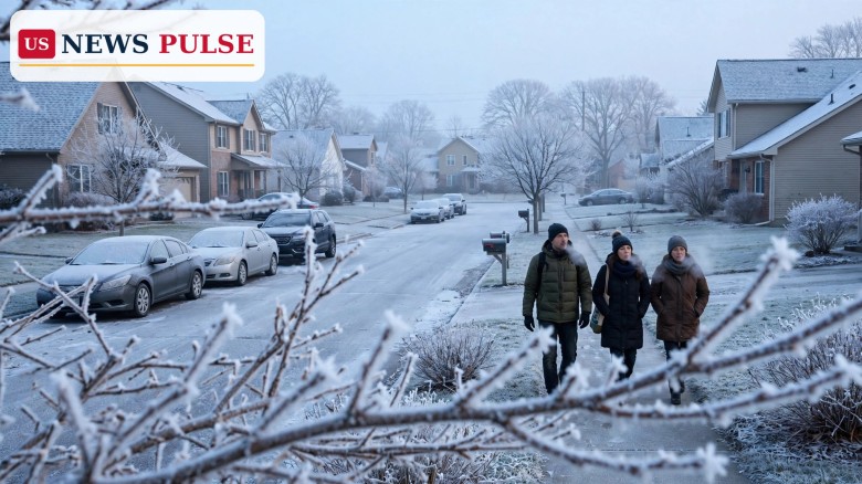
A blast of cold Canadian air is sweeping across the United States this weekend, bringing the season's first widespread freeze to more than 30 states and below-average temperatures to more than 280 million people. For millions of Americans, it will be the first sub-freezing temperature of the autumn, and for many it is arriving weeks later than usual.
The cold follows a departing storm that buried parts of New York State under more than a foot of snow. Frost and freeze alerts now stretch from eastern Oklahoma to the coastal Carolinas and deep into the South. The chill will not last long: the central United States is expected to warm again by the middle of next week, but the weekend ahead will feel as if winter has finally arrived.
Key Points
- The season's first widespread frost and freeze will reach more than 30 states over the weekend of November 14-15, 2026.
- More than 280 million people will experience below-average temperatures, with the first sub-freezing readings of autumn for millions.
- The departing storm dropped more than a foot of snow on parts of New York State, including 12.5 inches at Hartwick and 12 inches at Burlington.
- Frost and freeze alerts cover cities from Tulsa and Little Rock to Birmingham, Atlanta and Raleigh, and reach into southern Alabama.
- The cold snap is expected to be brief, with the central United States warming again by mid-week.
What Happened
A powerful storm system that moved across the Northeast this week is now heading out to sea, and a surge of cold Canadian air is pouring in behind it. The storm dropped heavy snow across upstate New York before it left. Hartwick recorded 12.5 inches, Burlington measured 12 inches, Exeter Center saw 11.5 inches and Cherry Valley picked up 10 inches, with three to seven inches falling across the Catskills by Friday morning.
As the storm departs, the cold is spreading fast. Frost and freeze alerts now stretch from eastern Oklahoma to the coastal Carolinas and into southern Alabama, covering Tulsa, Little Rock, Birmingham, Atlanta and Raleigh. Forecasters expect the freeze to reach deep into the Southeast, a region that has stayed unusually warm through much of the autumn.
The wind will make the cold feel sharper. Forecast wind chills are 24 degrees on Saturday and 27 on Sunday in Chicago, 34 and 40 in New York, 31 and 32 in Atlanta, and 35 and 32 in Tallahassee, Florida. Lake-effect snow showers are expected in the Adirondacks, the Berkshires and the Green and White Mountains, and minor coastal flooding is possible near Cape May, New Jersey.
Background and Context
The first freeze is arriving late for much of the country. Nashville's first freeze is running about 12 days later than normal, and millions of people across the South and East have yet to feel a sub-freezing temperature this autumn. A strengthening El Niño has driven prolonged autumn warmth across much of the United States, pushing the start of the cold season back by weeks in many places.
The late arrival contrasts with the wild weather elsewhere this month. A nor'easter brought a tornado warning at JFK Airport and tornadoes to Delaware and New Jersey, while a winter storm dumped up to 24 inches of snow on the Sierra Nevada in California. The weekend freeze is the next chapter in a restless November that has swung from record warmth to snow and now to widespread cold.
First Widespread Freeze: What to Expect This Weekend
Saturday will be the coldest day for many places. Chicago will feel like the mid-20s through the weekend, New York will see wind chills in the 30s, Atlanta faces wind chills near freezing on both days, and even Tallahassee, in the Florida Panhandle, will feel like the low to mid-30s. Overnight lows will dip below freezing across a broad band of the country, from the Plains through the mid-South and into the Carolinas.
Gardeners and farmers in the Southeast should expect the first killing frost of the season, and tender plants should be brought inside or covered before nightfall. Drivers should watch for icy patches on bridges and overpasses, especially in the Northeast, where the departing storm left wet roads behind.
The cold will be most noticeable in the morning. Frost will coat rooftops, lawns and car windshields across much of the East, and many people will scrape ice for the first time this season. It is a familiar autumn ritual, but this year it follows weeks of unusually mild weather, which makes the sudden drop feel sharper than usual.
Reactions
Forecasters have issued frost and freeze alerts across the affected region, urging residents to prepare. The advice is the standard autumn routine: protect outdoor pipes, bring potted plants indoors, cover sensitive vegetation, and make sure pets have warm shelter. Homeowners are also reminded to check on elderly neighbours, who are more vulnerable when temperatures fall quickly after a long warm spell.
Why It Matters
A first freeze is more than a weather milestone. For farmers and gardeners, it ends the growing season and can damage crops still in the field. For households, it means the first real heating bills of the winter and a reminder to winterise homes before the deeper cold arrives. For the energy system, it is the first test of the season, as demand jumps sharply after weeks of mild weather.
The timing matters too. A freeze that arrives weeks late can leave plants and infrastructure unprepared, and it can catch people off guard after weeks of warm autumn days. After this weekend, cold air will be a regular visitor rather than a rare one.
What Happens Next
The cold snap is expected to be short-lived. The central United States should warm again by mid-week, with temperatures climbing back toward normal for November. The East will stay chilly a little longer, but the widespread freeze is not expected to linger.
Frequently Asked Questions
How many states will feel the freeze?
More than 30 states, from the Plains and Midwest through the mid-South and into the Carolinas and southern Alabama.
How cold will it get?
Wind chills of 24 degrees in Chicago on Saturday, low 30s in Atlanta and Tallahassee, and mid-30s in New York. Overnight lows will fall below freezing across a wide area.
Where did the most snow fall?
Parts of New York State received more than a foot of snow, led by Hartwick with 12.5 inches, Burlington with 12 inches, Exeter Center with 11.5 inches and Cherry Valley with 10 inches.
Why is the first freeze so late this year?
A strengthening El Niño has kept autumn unusually warm across much of the country. Nashville's first freeze is about 12 days later than normal.
When will it warm up again?
The central United States is expected to warm by mid-week, and the cold snap is forecast to be brief rather than the start of a long cold spell.
For more on the wild weather sweeping the country this month, see our coverage of the California winter storm that brought up to 24 inches of snow to the Sierra, the nor'easter tornado warning at JFK Airport, and the record king tides flooding US coasts.
© 2026 US News Pulse. All rights reserved.
 Print
 Save