


 | Today's Date:





Brevard Flooding: Florida Schools Close as 11.9 Inches of Rain Swamp East Coast
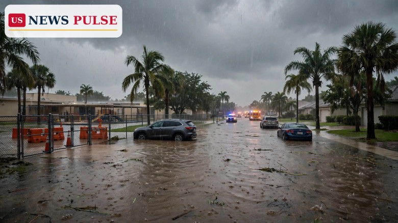
Brevard County flooding closed every public school in the county on Monday, November 2, 2026, after almost a foot of rain fell in parts of Florida's east coast in 24 hours and forecasters warned that more heavy rain was still to come. Brevard County schools closed for the day as flooded roads, a county-wide flood watch and a sheriff's warning to stay home turned an already sodden start to November into one of the wettest days of the year for the Space Coast.
The heaviest total reported by the National Weather Service office in Melbourne was 11.9 inches in West Melbourne over the previous 24 hours, with 7.5 to 9 inches across the Melbourne and Palm Bay area. Brevard County Sheriff Wayne Ivey encouraged residents to stay home unless travel was necessary, as flooded roads made driving dangerous across the county. The school district said early on Monday that the closure was made to protect pupils, staff and families while heavy rain continued, and its website carried a blunt weather alert: schools are closed today due to inclement weather.
Key Points
- Brevard Public Schools cancelled all classes on Monday, November 2, 2026, because of flooding and severe weather across central Florida.
- West Melbourne recorded 11.9 inches of rain in 24 hours, with 7.5 to 9 inches across Melbourne and Palm Bay, according to the National Weather Service in Melbourne.
- Brevard County Sheriff Wayne Ivey urged residents to stay home unless travel was necessary, as flooded roads spread across the county.
- A flood watch remained in effect for east central Florida through 7 p.m. on Monday, with another 1 to 3 inches of rain expected and a 5 to 10 percent chance of 5 inches or more in Brevard County.
- South Florida was also under a flood watch through Monday evening, with 1 to 3 inches more expected and up to 9 inches possible in isolated spots.
What Happened
Rain that had already soaked Florida through the weekend intensified again on Monday morning. Early rain bands brought 2 to 3 inches to parts of Brevard County and, forecasters said, could continue until midmorning as persistent thunderstorms sat over the county. Radar on Monday showed a wide swath of intense rain across central Florida, from coast to coast, while live updates from the Palm Beach Post described surf crashing over sea walls and many streets and highways in south and central Florida becoming impassable.
In Brevard County, the rain fell on ground that was already saturated. That, forecasters said, was what turned heavy rain into flash flooding: water had nowhere to go, so it pooled on roads, in neighbourhoods and in low-lying areas. The district's decision to close schools for the whole county, rather than a handful of campuses, underlined how widespread the disruption was. A lane on Interstate 4 in Osceola County was also closed because of flooding, according to the Florida Highway Patrol, a reminder that the travel risk extended well beyond Brevard itself.
The totals elsewhere in the state showed how uneven the storm had been. Palm Beach Gardens recorded 8 to 13 inches, especially along the Turnpike in the Belvedere area, while Palm Beach International Airport recorded 4.28 inches. Radar indicated 6 to 8 inches in Glades and Hendry counties and in Highlands, DeSoto and Hardee counties. Orlando had recorded 1.84 inches since midnight, while Miami recorded 1.57 inches, with 3 to 5 inches in parts of Pinecrest and Coral Gables. In other words, the worst of the rain was concentrated in a corridor running from the Treasure Coast through east central Florida and into Palm Beach County, with Brevard County at its centre on Monday morning.
Background and Context
Monday's closures did not come out of nowhere. Okeechobee County, south of Brevard, had already closed its schools and county offices on Monday after communities around Lake Okeechobee were inundated with 5 to 7 inches of rain on Sunday, and a shelter was opened at Seminole Elementary School. The southern half of Florida had been under a flood watch through at least early Tuesday, and forecasters had warned that another 1 to 3 inches was possible south of Interstate 4, with isolated totals of 3 to 5 inches where storms trained over the same ground.
The wider pattern was a slow-moving, moisture-laden system sitting over the Florida peninsula. The National Weather Service in Miami said a flood watch continued through Monday for south Florida, with more rounds of showers expected through the afternoon and into the evening. Because the rain was moving slowly, forecasters said, the heaviest rain might not hit every area, but the worst-hit places could still receive several more inches. In southwest Florida, another inch or so was possible, with up to 2 inches in some places, while northeast Florida could see a quarter to half an inch more through November 3, with locally heavier amounts coming in off the Atlantic.
Florida's geography makes this kind of event especially disruptive. Much of the peninsula is low-lying, drainage systems depend on canals and retention ponds that fill quickly in sustained rain, and coastal areas face the added problem of high tide pushing water back inland. When saturated ground, a slow-moving storm and a coastal flood risk combine, roads can flood even without a named tropical storm, and school districts — which must move thousands of children by bus across flooded routes — often have little choice but to close.
Brevard County Flooding: What the Forecast Says Next
The immediate question for Brevard County residents on Monday was how much more rain would fall. National Weather Service meteorologist Cassie Wishard, speaking to Florida Today, said an additional 1 to 3 inches could be expected for the rest of east central Florida, with a 5 to 10 percent chance of 5 inches or more in Brevard County itself. The flood watch for east central Florida ran through 7 p.m. on Monday, with the heaviest rain expected in Brevard County.
For south Florida, meteorologist Chris Fisher said more rounds of showers were expected through Monday afternoon and into the evening, with the heaviest rain potentially bringing several more inches to the worst-hit areas. In southwest Florida, meteorologist Matt Anderson expected rainy conditions until the end of the day, with another inch or so possible and up to 2 inches in some places. The Palm Beach Post's live updates put the south Florida picture in similar terms: a flood watch through the evening, 1 to 3 inches more expected, and up to 9 inches possible in isolated areas, with the potential for rapid flash flooding.
Further ahead, the outlook was for a gradual improvement rather than a sudden clearing. Rain chances were expected to decrease from mid to late week, but above-normal moisture was forecast to remain over Florida through the middle of the week. A strong cold front was expected to move through the western Panhandle on November 4, with showers and thunderstorms likely, although the severe-weather threat was low at that stage. That front could reach east central Florida by November 6, bringing temperatures closer to seasonal averages, with a further cold front around November 10 expected to push temperatures below normal.
Reactions and Quotes
The clearest public-safety message on Monday came from Sheriff Ivey, who encouraged Brevard County residents to stay home unless it was necessary to travel, because of flooded roads. The message, carried in Florida Today's live coverage, reflected the main danger in this kind of flooding: not the rain itself, but drivers attempting roads that look passable and are not. Floodwater can hide washed-out surfaces, stalled vehicles and fast-moving currents, and even a few inches of moving water can sweep a car off the road.
The school district's own message was equally direct. Its early-Monday notice said the decision to cancel school for the day had been made to protect pupils, staff and families as heavy rain continued, and its website alert read simply: "Weather Alert! Schools are closed today due to inclement weather." No reopening time was given on Monday morning; the district said it would continue monitoring conditions, a standard position when the forecast still carries a risk of further flash flooding through the evening.
Forecasters, for their part, were careful to stress uncertainty as well as risk. The 5 to 10 percent chance of 5 inches or more in Brevard County was not a prediction that it would happen, but a warning that it could not be ruled out while thunderstorms kept training over the same saturated ground. That distinction matters for residents deciding whether to travel: the forecast did not guarantee further flooding, but it left the risk high enough that staying home remained the safest advice through Monday evening.
Why It Matters
Monday's closures matter for three reasons. First, they show how a non-tropical rain event can still shut down a whole county's schools and snarl travel across a region, without a hurricane name or a landfall to warn people in advance. Second, they underline the compounding effect of saturated ground: after a wet weekend, even a further 1 to 3 inches can produce flash flooding that a drier landscape would have absorbed. Third, they come at the start of a week when Florida, like the rest of the country, is heading into Election Day on Tuesday, November 3 — and while the heaviest Florida rain was expected to ease before then, flooded roads and school closures are a reminder of how quickly weather can disrupt ordinary life.
For families, the practical impact was immediate: a lost school day, disrupted commutes and, for some, water approaching homes. For emergency managers, the event was a test of the same systems — flood watches, road closures, shelter readiness and public messaging — that are used in larger storms. The fact that Okeechobee County had already opened a shelter on Monday, and that Brevard County moved early to close schools, suggests those systems were activated before the worst of Monday's rain arrived, rather than after it.
What Happens Next
Through Monday evening, the watch remains the key document: a flood watch for east central Florida through 7 p.m., and a flood watch for south Florida through the evening, with flash flood warnings and advisories in several counties. Residents should expect further updates as rain bands move through, and should treat any flooded road as closed, even if no barrier is in place. The National Weather Service and local sheriff's offices are the authoritative sources for road closures and any evacuation advice.
From midweek, rain chances should gradually decrease, although moisture will linger through the middle of the week. The cold front expected in the Panhandle on November 4 and in east central Florida by November 6 should bring a more seasonal feel, with a further front around November 10 pushing temperatures below normal. For Brevard County, the immediate recovery — draining flooded roads, checking school campuses and clearing debris — will begin once the rain eases and the flood watch expires, with the district expected to confirm reopening plans for Tuesday once conditions allow.
Frequently Asked Questions
Why did Brevard County schools close on November 2, 2026?
Brevard Public Schools cancelled all classes on Monday because flooding and severe weather affected parts of central Florida, and the district said the closure was made to protect pupils, staff and families as heavy rain continued.
How much rain fell in Brevard County?
West Melbourne recorded 11.9 inches in 24 hours, with 7.5 to 9 inches across Melbourne and Palm Bay, according to the National Weather Service office in Melbourne.
Is more rain expected in Florida on Monday?
Yes. Another 1 to 3 inches was expected for east central Florida, with a 5 to 10 percent chance of 5 inches or more in Brevard County, and south Florida could see 1 to 3 inches more, with up to 9 inches possible in isolated spots.
What did Sheriff Wayne Ivey advise residents to do?
He encouraged Brevard County residents to stay home unless travel was necessary, because of flooded roads across the county.
When will the rain ease in Florida?
Rain chances were expected to gradually decrease from mid to late week, although above-normal moisture was forecast to remain through the middle of the week, with a cold front reaching east central Florida around November 6.
Related coverage on US News Pulse:
Leave a Comment