


 | Today's Date:





Oklahoma Panhandle Storm Rips Barns Apart as Severe Threat Returns Monday Night
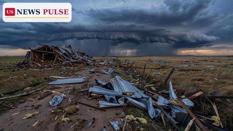
KEYES, Oklahoma — An Oklahoma Panhandle storm tore barns apart and threw twisted metal across a road near Keyes late Sunday night, hours before forecasters warned of a fresh round of severe weather across Oklahoma, Kansas and north Texas on Monday night. The damage, photographed in the small Cimarron County town after a tornado-warned storm moved through shortly before 11:30 p.m., is the first confirmed storm damage of a volatile election-eve weather stretch — and it may not be the last.
No injuries were reported in the accounts checked by US News Pulse, and officials have not confirmed that a tornado touched down. What is confirmed is the warning itself, the radar signature behind it and the wreckage left behind: barns ripped open, metal roofing and siding scattered across the street, and multiple buildings damaged in and around Keyes, a Panhandle town about 25 miles northeast of Boise City.
Key Points
- A tornado-warned storm hit the Keyes area of Cimarron County, Oklahoma, shortly before 11:30 p.m. Sunday, November 1, 2026, damaging barns and other buildings.
- The National Weather Service in Amarillo issued a tornado warning at 11:18 p.m. CST for northeastern Cimarron County and northwestern Texas County, citing radar-indicated rotation.
- Photographs from the scene showed barns torn apart and metal structures thrown across the street; no injuries were reported in the reports checked.
- A second tornado warning followed late Sunday near Eva in Texas County, and forecasters say more severe storms are likely Monday afternoon and evening.
- The Storm Prediction Center has placed parts of Kansas, Oklahoma and north Texas under a Level 2 of 5 severe-weather risk for Monday, with damaging winds the main threat.
What Happened
Severe storms moved into the Oklahoma Panhandle late Sunday night as a powerful system crossed the southern Plains. The National Weather Service office in Amarillo, Texas, issued a tornado warning at 11:18 p.m. CST on November 1 for northeastern Cimarron County and northwestern Texas County, in effect until 11:45 p.m.
At 11:18 p.m., the warning said, a severe thunderstorm capable of producing a tornado was located about 10 miles northeast of Keyes, or about 25 miles northeast of Boise City, moving northeast at 55 mph. The rotation was indicated by radar rather than confirmed by spotters on the ground — a distinction that matters, because a tornado warning can be issued on a strong radar signature before anyone sees a funnel, and the National Weather Service typically sends survey teams afterward to determine whether a tornado actually touched down and how strong it was.
The warning listed the hazards plainly: flying debris would be dangerous to anyone caught without shelter, mobile homes would be damaged or destroyed, and damage to roofs, windows and vehicles was expected, along with tree damage. Locations in the path included Sturgis, a small community in the same corner of the Panhandle. The warning urged residents to take cover immediately, noting that tornadoes are difficult to observe at night.
Shortly before 11:30 p.m., the storm reached the Keyes area itself. Photographs provided by Cimarron News and carried by Cedar News showed the aftermath: barns with roofs and walls peeled away, twisted sheets of metal roofing thrown across the street, and debris strewn across the flat prairie ground. Multiple buildings showed damage, the reports said. The pictures, taken after the storm passed, became the defining images of the night in the Panhandle — a landscape of bent metal and splintered timber under a clearing sky.
A second tornado warning followed later Sunday night. At 11:55 p.m. CST, a severe thunderstorm capable of producing a tornado was located about 6 miles north of Eva, or about 29 miles northwest of Guymon in Texas County, moving northeast at 45 mph. That warning covered parts of Texas County as the line of storms continued its northeast march across the Panhandle.
By Monday morning, the Keyes damage was prominent enough to lead local television coverage. The News 9 morning newscast in Oklahoma City on Monday, November 2, flagged tornado damage in Keyes among the stories catching its newsroom's eye, alongside the state's other overnight developments. No injury reports, road closures or damage estimates had been published in the reports checked by Monday afternoon, and no official damage survey result had been released — a normal gap in the first hours after a nighttime Panhandle storm, when survey crews must travel long distances across sparsely populated counties.
Background: The Panhandle and a Volatile Weekend
The Oklahoma Panhandle is a narrow strip of prairie running west from the main body of the state, bordered by Texas to the south, Kansas to the north and New Mexico and Colorado to the west. Cimarron County, at the far western tip, is the state's least populous county, and Keyes is a small farming community there, with Boise City — the county seat — the nearest larger town. Texas County, immediately to the east, includes Guymon, the Panhandle's largest city, and smaller communities such as Eva and Sturgis.
That geography shapes how Panhandle storms are experienced. Homes, barns and outbuildings can sit miles apart, and a single storm cell can cross an entire county in under half an hour at highway speed — the Keyes storm was moving northeast at 55 mph. Damage to farm buildings, rather than to dense neighbourhoods, is the typical signature of a Panhandle severe storm, and it is also why official damage assessments can take a day or more: surveyors must cover enormous distances to document what happened.
The Keyes storm capped a weekend of punishing weather across the United States. In Florida, torrential rain swamped Brevard County on Monday, closing all public schools there, with West Melbourne recording 11.9 inches of rain in 24 hours. Across the Southwest, more than 10 rivers, creeks and washes in Arizona and southwest Colorado rose past major flood stage, with record crests on the Little Colorado River near Winslow and the Gila River near Solomon, and evacuations and rescues in at least a dozen counties. Those floods and the Panhandle storms were separate chapters of the same restless autumn pattern — a season in which warm, moist air and strong upper-level winds have repeatedly collided over the middle of the country.
November tornadoes are less common than spring ones, but they are far from unheard of in Oklahoma. The state's secondary severe-weather season in autumn arrives when cold fronts begin pushing south while Gulf moisture lingers, and the Panhandle, sitting at the crossroads of those air masses, is often first in line. Nighttime tornadoes are especially dangerous because people are asleep, visibility is poor and the usual visual cues — a dark funnel against the sky — are invisible.
Oklahoma Panhandle Storm: What the Warnings Mean
Understanding Sunday night's warnings helps explain why forecasters took the Keyes storm so seriously even before the damage photos emerged. A tornado warning means a tornado is imminent or occurring, based on radar or a spotter report, and it is the most urgent of the National Weather Service's severe-weather alerts. It is distinct from a tornado watch, which means conditions are favourable for tornadoes across a broad area, and from a severe thunderstorm warning, which covers damaging winds and large hail without a tornado threat.
Sunday night's Keyes warning was radar-indicated, meaning forecasters saw rotation in the storm on Doppler radar strong enough to justify a warning even without a confirmed sighting. Radar-indicated tornadoes sometimes never touch down, and sometimes they do touch down in unpopulated areas where no one sees them. That is why the damage photographs matter so much: they are the ground truth that turns a radar signature into a documented storm event, and they are what survey teams will use, alongside radar data, to judge whether a tornado occurred and how powerful it was.
The second warning, near Eva, followed the same pattern — a radar-indicated storm moving northeast at 45 mph late at night, when most residents were indoors. Together, the two warnings show a line of rotating storms tracking across the Panhandle from Cimarron County into Texas County over the course of about 40 minutes, a classic signature of a fast-moving autumn squall line with embedded rotation.
For residents, the practical message of a nighttime tornado warning is unchanged from the daytime one: go to an interior room on the lowest floor of a sturdy building, away from windows, and protect your head. Mobile homes offer little protection in a tornado and should be abandoned for a sturdier shelter or a community storm shelter. In the Panhandle, where distances to shelter can be long, forecasters stress having a plan before the warning sounds — a lesson the Keyes storm, arriving just before midnight on a Sunday, underlined.
Reactions: Forecasters and Local Coverage
Local coverage on Monday morning treated the Keyes damage as the Panhandle's headline weather story. News 9, the Oklahoma City television station, singled out tornado damage in Keyes in its Monday morning newscast summary, a sign that the damage had registered beyond the Panhandle's small local news outlets. Cedar News, carrying photographs provided by Cimarron News, described barns ripped apart and metal structures thrown across the street — the spare, factual language of a damage report filed before official survey results.
The National Weather Service's own language in the warning was its own form of reaction: urgent, specific and stripped of hedging. "Take cover now!" the warning said, followed by the reminder that tornadoes are difficult to observe at night. That bluntness is deliberate. Forecasters know that nighttime warnings compete with sleep, and they write them to cut through.
As of Monday afternoon, no statements from the governor's office, county emergency management or the National Weather Service's Amarillo office about the Keyes damage had appeared in the reports checked. That silence is not unusual: in a county as large and thinly populated as Cimarron, the first official word often comes only after survey crews have driven the damage path, sometimes a day later.
Why It Matters
The Keyes storm matters for three reasons. First, it is a reminder that Oklahoma's severe-weather season does not end with summer. Autumn cold fronts meeting lingering Gulf moisture can spin up dangerous storms in November, and they often do so at night, when they are hardest to see and easiest to sleep through.
Second, it is a warning shot for Monday night. The same broad weather pattern that produced the Panhandle storms is forecast to bring a much larger severe-weather episode to the more populated parts of Oklahoma, Kansas and north Texas on Monday afternoon and evening — the night before Election Day. A storm that damages barns in a town of a few hundred people is one thing; the same kind of storm over Oklahoma City, Tulsa or Wichita is another, with far more people, homes and polling-place preparations in its path.
Third, it tests the region's readiness at an awkward moment. Election officials across the Plains are finalising polling locations and early-voting logistics for Tuesday, November 3, and a Monday-night squall line with damaging winds, hail and possible tornadoes could disrupt travel, knock out power and force last-minute changes. Forecasters and election officials alike will be watching Monday evening's radar with unusual attention.
What Happens Next
The immediate next step is the official damage survey. National Weather Service teams are expected to examine the Keyes damage path to determine whether a tornado touched down, and if so, to rate it on the Enhanced Fujita scale and map its track. That finding will replace the current careful wording — "tornado-warned storm" — with a definitive answer, and it may take a day or more to arrive.
The bigger story, though, is Monday night. The Storm Prediction Center has placed a Level 2 of 5 severe-weather risk over south-central and eastern Kansas, western and central Oklahoma and north Texas for Monday. The National Weather Service office in Tulsa says storms could start as early as 1 p.m., with the most likely window from 7 p.m. to midnight, possibly extending to 2 a.m. Tuesday. Damaging gusts of about 70 mph and hail up to quarter size are the expected hazards in the Tulsa area, with the threat reaching Muskogee and eastern Oklahoma between about 11 p.m. Monday and 4 a.m. Tuesday.
News 9's forecast adds detail: isolated storms may try to develop between 1 p.m. and 4 p.m., with the highest chance of severe weather between 4 p.m. and 10 p.m., when numerous storms develop ahead of a dryline and push east. Eventually, a squall line is expected to form, and within that line, short-lived tornadoes are possible. The strongest storms could produce damaging winds up to 80 mph and hail from quarter to golf-ball size. By midnight, the severe threat is expected to be ending in western Oklahoma as storms move into far eastern Oklahoma.
Beyond Monday night, the threat moves into the Deep South on Election Day, Tuesday, November 3, while heavy rain spreads across the Midwest on Wednesday. A strong cold front will move through Oklahoma overnight Monday, bringing gusty north winds and cooler, calmer conditions for Election Day itself in the state — a welcome change, if the front arrives on schedule and the storms clear in time.
For Panhandle residents, the advice for Monday night is the same as it was Sunday night: monitor weather alerts through the evening, know where your nearest sturdy shelter is, and do not wait for visual confirmation of a tornado — especially after dark. The Keyes storm showed how quickly a quiet Sunday night can turn into a damage survey. Monday night, with a much larger population in the risk area, will be the real test.
Frequently Asked Questions
Did a tornado touch down in Keyes, Oklahoma?
Not confirmed yet. The storm was tornado-warned on radar-indicated rotation, and photographs show barns torn apart and metal thrown across the street. The National Weather Service will survey the damage to determine whether a tornado touched down and how strong it was.
Was anyone hurt in the Keyes storm?
No injuries were reported in the reports checked by Monday afternoon. Officials have not released any casualty information, and the damage accounts so far describe buildings and farm structures rather than injuries.
What areas are at risk on Monday night?
The Storm Prediction Center's Level 2 of 5 risk covers south-central and eastern Kansas, western and central Oklahoma and north Texas. The Tulsa area faces its most likely storm window from 7 p.m. to midnight, with Muskogee and eastern Oklahoma from about 11 p.m. to 4 a.m.
What are the main hazards on Monday night?
Damaging straight-line winds are the main hazard, with gusts of 70 to 80 mph possible in the strongest storms. Large hail up to golf-ball size and a few tornadoes — including short-lived tornadoes within a squall line — are also possible.
Will the storms affect Election Day voting on Tuesday?
The severe threat is expected to move into the Deep South on Election Day, while Oklahoma itself should turn cooler and windy behind a cold front. Voters in the Plains should still check local conditions and polling-place updates on Tuesday morning, especially in eastern Oklahoma, where storms may linger past midnight.
Related coverage: Southwest record flooding: rivers hit record crests as storm heads to Election Day; Brevard flooding: Florida schools close as 11.9 inches of rain swamp east coast; Florida flooding in Okeechobee: schools close as 5.7 inches of rain swamp lake area.
Leave a Comment